Improving Member States preparedness to face an HNS pollution of the Marine System (HNS-MS)
Towards a decision support tool
More than 2000 HNS are regularly carried by sea either in bulk or
packaged form and thus are a potential threat in case of a
pollution incident. When such an incident occurs, the priorities
are to assess the risk posed to the public and to the
environment and to identify the socio-economic assets that might
be impacted so as to take the necessary measures and
decisions.
In this project, we aim to build decision support tool demonstrator which will integrate the following features:
A simulation manager:
The mathematical model we are planning to develop will be a powerful tool which will be used to predict the drift, fate and behaviour of HNS spills. But in many cases, setting up and using such a model requires technical capabilities (such as computer programming) or direct access to computing servers. To extend the model’s user base to a wider audience within the emergency management community, we will develop an intuitive, easy to use simulation manager which will allow authorised personnel to quickly and efficiently setup and launch complex simulations, taking into account known or supposed characteristics of the spill (e.g. type of product, type and location of spill, physical and chemical specifications -- the simulation manager will be linked to the HNS database developed within the project). The calculations will then be performed remotely and results will be made available to the user. The simulation manager will give the possibility to each individual simulation owner to independently manage (review, visualise, delete, share) their simulations.
A post-processing tool:
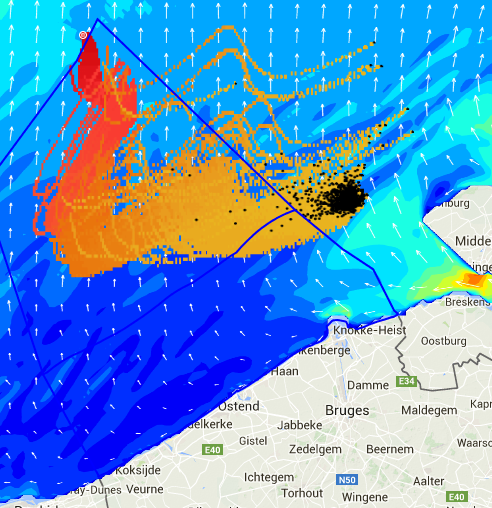
Three-dimensional mathematical simulations generate a lot of data which must be transformed to easily understandable assets such as data tables, maps and graphs. These assets must be tailored to end-users requirements and will include, at the minimum, drift trajectories, HNS concentration and residence time at the sea-surface, in the water column and at the seabed as well as the downwind areas impacted by the HNS evaporated fraction. Other advanced information such as the time evolution of the mass balance between evaporated, dissolved, sunken and floating fractions of the HNS may also be computed.
A visualisation tool:
The visualisation tool demonstrator will link and integrate many of the components developed within the frame of the project. It will allow registered users to visualise their simulations and access an array of data that should facilitate the decision-making process. This will include:
- Information on HNS substances (queried from the HNS database)
- Dynamic views of simulation results in the form of maps, graphs or data tables, with an easy to use, reactive and integrated user interface
- Overlays of met-ocean forcings (wind, wave, currents,...)
- Overlays of geographical layers depicting environmental and socio-economic vulnerabilities
- The ability to share with other registered users or to download simulation results
About the project
HNS-MS is a decision-support tool that Belgian and French maritime authorities as well as coastguard stations can activate in order to forecast the drift, fate and behavior of acute marine pollution by Harmful Noxious Substances (HNS) accidentally released in the marine system.
Contact us
Copyright © 2015–2026 HNS-MS Consortium
 HNS-MS has been funded by DG-ECHO under agreement ECHO/SUB/2014/693705 and runs from 1 January 2015 to 31 March 2017.